- Home
- About Us
- Products
- Media Video
- Application
- News
- Support
- Contact Us
 English


 |


| PDF Export | |
SW1000
Multi-level control: support the deployment of central clusters and the common use of multiple places; support the multi-cascade prevention and control of provinces, cities and counties; support the coordination, monopoly, preemption and other strategic scheduling of optoelectronic equipment at all levels;
Multi-mode unattended: support unattended warning zone mode and unattended photoelectric automatic scanning mode;
Water conservancy monitoring: support the access, display and over-limit alarm of various water conservancy-related data such as water quality, water level, flow rate, and rainfall;
High-definition offline map: support offline high-definition two-dimensional electronic map, two-dimensional satellite map, three-dimensional map; support photoelectric video, water quality and water level data, flow and rainfall data, river chief inspection data based on the comprehensive situation distribution display of maps; support the display of historical alarm information on the map and the use of heat map to display high-risk areas;
Photoelectric tracking: Support target intrusion tracking in key areas, identification tracking of personnel and vehicles, and photoelectric relay tracking;
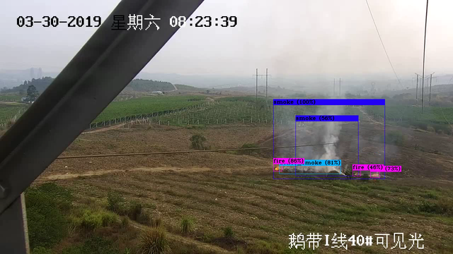
Intelligent algorithm: support floating debris detection, fishing detection, illegal sand mining detection; support personnel detection, vehicle detection and swimming personnel detection in the control area;
Support the statistical analysis of the status of optoelectronic equipment and various sensors, support the statistical analysis of various alarm data such as photoelectric, sensor, and manual inspection, and support the statistical analysis of various types of data displayed in real time by large-screen visualization.

Model | SW1000 Intelligent Water Conservancy Integrated Management Software |
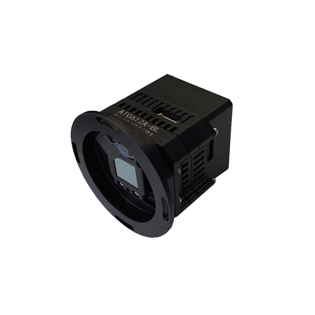
Applicable Devices* | Photoelectric turntable, photoelectric gimbal, 4G water level ball, universal security camera |
System Performance* | No less than 1000 channels of equipment access, not less than 200 channels of equipment at the same time alarm No less than 100 users are online at the same time |
Water conservancy monitoring | 1. Water shoreline: Support the management of water information in rivers, lakes, reservoirs and other waters; support the information management of sensitive water areas such as intersections, water intakes, sewage outlets, recoverable areas, and reserved areas; and support the market towns along rivers and villages along rivers Information management of locations; support the marking management of various prohibited areas such as no-swimming sections, no-mining areas, and no-fishing areas 2. Hydrological monitoring: Support data access of various hydrological sensors such as water level, water quality, flow rate, and rainfall 3. Remote fixed-point inspection: Support remote timed fixed-point automatic inspection, hidden danger identification, video evidence collection and alarm reporting in key river sections, sensitive waters, and prohibited areas 4. Mobile inspection scheduling: Support mobile inspection, route planning and guidance, task scheduling, river patrol punching, dangerous situation reporting, and abnormal behavior detection of inspection personnel 5. Multi-source alarm monitoring: support hydrological threshold alarm, photoelectric inspection alarm, manual inspection alarm; support rapid alarm notification, photoelectric linkage observation; support alarm video capture, evidence collection, positioning 6. Historical alarms: Supports list query of historical alarms, map distribution query, alarm video playback, alarm image review, and detailed review of alarm event disposal process; supports historical alarms Export and import, archive and download alarm event information |
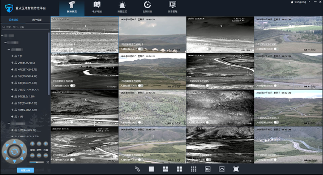
Video surveillance | 1. Video preview: Support single device connection, batch connection, drag connection, support single device disconnection, all disconnection, support automatic reconnection after video abnormal disconnection, support 1/3/4/6/9/16/25 screen preview, support multi-screen position exchange display, support TV mode display, support video window function button quick operation and right-click menu operation Support video manual recording, manual capture, and scheduled task recording 2. PTZ control: support eight-way gimbal control, support zoom, focus, aperture lens control, support horizontal angle positioning, pitch angle positioning, field of view angle positioning, support for photoelectric equipment 3D click positioning, frame selection zoom out and zoom out positioning, support mouse gesture control gimbal; support equipment collaborative scheduling, exclusive control, preemptive control 3. Preset position & cruise: support hardware preset position, software preset position, preset position watch; support fan sweep, line scan, hardware preset position cruise, software preset position cruise detection; support day and night mode patrol, timed task inspection 4. Remote configuration: Support remote switching on and off of optoelectronic equipment, restart, refrigeration thermal image on/off, stable image adjustment, remote setting of camera parameters, support remote setting of thermal image alarm threshold 5. Information overlay: Supports superimposing real-time orientation information, lens field of view information, bandwidth traffic information, ranging information, and preset position names in the video; supports overlay display algorithms to identify target information such as people, cars, and boats; supports alarm video recordings, alarm captures, and superimposes the orientation information of the target. Pitch information, latitude and longitude information, support the integration of AR tag intelligent information 6. Status monitoring: Support real-time monitoring of the connection status and fault status of optoelectronic equipment, support monitoring of horizontal azimuth, pitch orientation and field of view angle 7. Video playback: Support local video playback, alarm video playback, disk array video playback, NVR, IPC device video playback, support fast forward, slow playback, single frame playback and other playback operations, support video summary playback 8. Support user view rotation 9. Support multi-monitor N* (1/3/4/9/16/25) video preview |
Intelligent algorithms | 1. Object recognition: Support visible light, thermal imaging video for people, vehicles, boats, drones (optional) and other target detection; support Enhance the accuracy of alarms through the recognition of people, vehicles and boats 2. Special scene detection: Support floating debris detection on the water surface, swimming detection in dangerous areas, illegal fishing detection and illegal sand mining detection 3. Target tracking: support target intrusion tracking, frame tracking, identification tracking, support optoelectronic equipment hardware tracking and control, back-end software algorithm scheduling tracking, support temporary tracking of alarm targets, automatically adjust the focal length during the tracking process, dispatch algorithm for target identification, and adjust the tracking status according to the recognition results 4. Video summary (optional): Support video summary extraction of alarm video, support, people, vehicles, boats, swimming, fishing, sand mining, floating objects, unmanned aerial vehicles (optional) and other target summary information recording 5. Panoramic stitching: support visible light panoramic stitching, thermal imaging panoramic stitching, support horizontal 360 °, pitch ≥ 50 ° seamless panoramic stitching; support panorama upload, download function; support panorama mode monitoring display; support in panorama to mark the current field of view, preset position, alarm position in the panorama Support linkage photoelectric through panoramic position click 6. Regional intrusion alarm: Support intrusion alarm, cross-border alarm, support intrusion detection personnel, vehicles, ships screening and filtering function |
Electronic maps | 1. 2D map: support offline high-definition 2D map; support electronic map, Google satellite map, sky map, vector map switching; support map distance measurement, area measurement, point line polygon layer drawing of map; support map drag, zoom in, zoom out operation; support scale bar, eagle eye view; support offline map drag range limitation; support administrative boundary highlighting; support map different background color mode display 2. 3D map (optional): Support satellite map 3D rendering display, support the function of local 3D map transition switching in 2D map, support 3D projection effect display under distance measurement, area measurement, point and line surface drawing and other functions 3. Situation distribution: Supports the comprehensive situation distribution display based on 2D/3D maps (optional) such as optoelectronic equipment, rivers and lakes, sensitive waters, prohibited areas, real-time water level information, alarm information, etc Support photoelectric equipment video pop-up observation and cloud mirror function scheduling, support map counter-control photoelectric equipment 4. Supports the elevation positioning technology of the target, and the accuracy of the actual measurement position ≤50m 5. Support heat maps based on 2D/3D maps (optional) to display the distribution of police situations 6. Box selection search: Support map box selection search function, support the search results classification filter query, positioning and photoelectric guidance viewing |
External devices | 1. Support gyro stabilization control 2. Support electronic compass, laser ranging and other data access 3. Support water quality, water level, rainfall and other types of sensor data access 4. Supports access to webcast devices 5. The center side supports access to SMS cat, sound and light alarm, and SMS platform |
Interface protocol | 1. Access protocols: RTSP, GB28181 (optional), ANDVIF video protocol access, support for equipment protocol access from mainstream manufacturers such as Hikvision, Dahua, and Uniview, and access to Huawei video platforms 2. Secondary development: support SDK secondary development, support Restful API platform docking, support RTSP, GB28181 (optional), WebRTC ( Optional) and other formats of video streams 3. Support the access of radar protocols of domestic mainstream manufacturers 4. Support for docking support of domestic operating systems |
※ The system application is related to the protocol and functional characteristics of the camera equipment, the system performance and the hardware resources of the operating environment, please contact us according to the actual situation.